Strong winds are set to hit parts of Scotland, with the Met Office issuing a yellow ‘be aware’ warning.
Gusts of 60 to 65mph are expected across parts of the north-west, particularly affecting the Western Isles.
Speeds of 70 to 75mph could be felt in more exposed parts of the country, such as Barra and North and South Uist.
There were also high winds across the central belt on Friday morning.
The caution will kick in from 3pm and remain in place until 5am on Saturday morning.
Winds will likely pave the way way for much wetter conditions on Saturday.

STV meteorologist Sean Batty said: “A low pressure system is approaching the north west of Scotland today and will bring windy conditions and very wet conditions in some area over the coming days.
“This weather system is fairly vigorous for the time of year, mainly because it drew in some warmer air from a tropical storm that clipped the east of the US earlier this week, which has injected a bit more life into it. Because it’s got a little tropical air in it, it’s also carrying more moisture, which will bring a lot of rain to some areas on Saturday.
“The windiest conditions will affect the north west of Scotland through Friday and into Saturday and could bring wind gusts around 60mph for the likes of the Small Isles, Tiree, Coll, western Skye. Parts of the Western Isles could have stronger gusts, such as North & South Uist, Benbecula and Barra, where up to 75mph is possible.
“The winds here will ease through Saturday, but it’s likely a peak in winds will spread through the central lowlands on Saturday afternoon with gusts around 40mph.
“Gusts could hit 50mph for a time across Fife, Dundee and Edinburgh as the westerly winds exit the lowlands and head out into the Tay and Forth.
“The wettest conditions on Saturday will be across the west of the country, with around 10-20mm fairly widely. It will be particularly wet around the Lochaber, Lorn and western Badenoch areas with as much as 40-50mm falling in some spots, which is almost all the rain we’ve had so far this month falling in just one day.
“While this will come as unwelcome news for many, the rain will be welcome news for many farmers and gardeners after what has been a very dry few months.”
The Met Office advised those using the roads during lockdown of potential delays to road and rail transport.
Delays for high-sided vehicles on exposed routes and bridges are likely, while some short term loss of power in certain communities is possible.
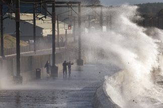
The national weather service also advised it is likely some coastal routes, sea fronts and coastal communities will be affected by spray and large waves.
Follow STV News on WhatsApp
Scan the QR code on your mobile device for all the latest news from around the country