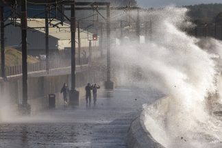
Commuters have been warned of potential travel disruption with more snow, ice and wind on the way.
Most of the country will be hit by heavy hail, sleet and snow showers throughout Monday night and Tuesday.
A yellow ‘be aware’ weather warning is currently in place but could be raised to amber for Tuesday.
The areas expected to be worst affected will be in the north and west of the county, including the central belt, Lanarkshire, Ayrshire and Argyll.
It comes after disruption throughout Monday in the wake of Storm Ciara, which battered parts of Scotland over the weekend.
STV meteorologist Sean Batty said: “We’ll continue to see heavy hail, sleet and snow showers throughout Monday and Tuesday in the north and west – fewer in the north east.
“My concern is that these showers will come through quickly and dump fairly sizeable amounts of snow and hail in short periods which is difficult to clear from the roads, especially during busy periods on the motorways when traffic isn’t able to move. “
Heavy sleet and snow will move south across central and southern Scotland on Monday night and Sean has warned over the potential of travel disruptions on the roads from rush hour.
He continued: “This is expected to be more rain and sleet at low levels, although it’s something to watch carefully as snow may fall to lower levels for a time.
“Higher up this still will be of snow, so there’s a possibility of some travel issues on the higher parts of the M77, M74 and M8 from around the evening rush hour this evening.
“Freezing level falls on Monday night with the risk of ice in quite a few areas and, again there will be frequent snow and hail showers affecting the north and west.
“I would say there’s a much higher chance of travel disruption on Tuesday from snow, with frequent snow showers affecting the central belt and south west.
“There’s a risk of more prolonged spells of snow coming in for a time on Tuesday evening/night, and again if these hit during a particularly busy time on the roads we could have major issues.
“The warnings as they stand are a yellow, but Tuesday’s warning is only one step away from being a high-impact event and means that any escalation will move this to an amber warning.”
The current yellow warning for wind, snow and ice is in place until Wednesday afternoon.
Just before 7pm on Monday snowy showers were causing some ‘treacherous’ driving conditions in Glasgow.
And just before 9pm on Monday the Queensferry Crossing was closed to all traffic as a safety precaution due to ice and snow falling from cables.
Traffic Scotland say it is “highly likely” that the Queensferry Crossing will remain closed over night and into the morning rush hour.
Follow STV News on WhatsApp
Scan the QR code on your mobile device for all the latest news from around the country