Latest updates
-
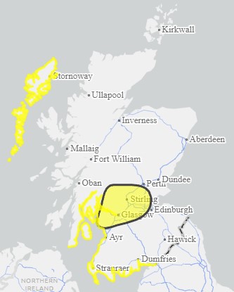
 Met Office weather warning for wind is in force across central and southern Scotland
 - SEPA has issued 18 regional flood alerts and 40 local flood warnings
- RAC warns of ‘extremely challenging’ conditions for drivers
- Gusts of 50-60mph are expected widely, with 70mph winds in exposed locations
- Limit on train speeds to come into force at midday
- About 70 flights departing and arriving at UK airports before midday on Saturday have already been cancelled
- Forth Road Bridge has been closed to all traffic
Storm Kathleen has brought strong winds and the risk of flooding across Scotland disrupting travel.
A Met Office weather warning for wind is in force across central and southern Scotland alongside widespread flood alerts issued by SEPA.
It comes after much of the country saw heavy rain and snow cause disruption to travel on Friday.
“The whole of Scotland will experience blustery conditions, but the strongest winds will affect the Hebrides on Saturday and Sunday with the risk of severe gales and a good chance of gales over the mainland, which is unseasonable for April,” said STV meteorologist Sean Batty.
Gusts of 50-60mph are expected quite widely, with the possibility of 70mph gusts in exposed coastal locations and mountains.

Network Rail said a limit on train speeds would be brought into force from midday on Saturday for safety reasons. The railway operator warned those travelling at the end of the Easter holidays that their journeys may take longer than normal.
“Hillwalkers should take note of these severe conditions,” Sean warned
“It’s likely the stronger winds at the weekend will disrupt ferry travel around the north and west of the country, and given that it’s the spring holidays and routes may be busier than normal this could be more impactful.”
Scotland’s Environment Protection Agency (SEPA) has issued 18 regional flood alerts and 40 local flood warnings across the country.
Vincent Fitzsimons, SEPA’s Flood Duty Manager, said: “Across the weekend, Scotland is braced for impacts from Storm Kathleen including very high winds and coastal flooding in western areas.
“Flooding impacts are expected across western coastal areas throughout the weekend. Impacts start in the Solway coast and Firth of Clyde on Saturday and then move around the coast to the eastern side of the country over the next few days.
“Of particular concern is likely impact to communities in the Western Isles and Orkney late Saturday and across Sunday.
“On top of already high tides, Kathleen will bring a storm surge and large waves. This combination is particularly dangerous – especially around high tides.
“There is real danger to life from wave overtopping, particularly around causeways, coastal roads and paths. Disruption to travel and infrastructure is possible, as is isolated flooding to coastal properties and communities.
“While the risk is greatest around high tide times, our message is clear : take extra care if you are near the coast at any point and stay well clear of waves and water. Be careful when travelling around exposed coastal areas and don’t walk or drive through flood water as there may be hidden hazards.
“Flood Alerts and Warnings are in place so stay up to date though our website. We will continue to work with the Met Office to monitor the situation 24/7 and review regional Flood Alerts and local Flood Warnings as required.”
 SEPA
SEPAThe Met Office said Storm Kathleen “will bring a spell of very windy weather to western areas of the UK this weekend.”
On Saturday, a deep area of low pressure will arrive from the southwest bringing unseasonably strong winds to Ireland and western parts of the UK.


The yellow weather warning, in place from 8am until 10pm, covers Glasgow, Edinburgh and Stirling, Argyll, Arran and Islay and stretches down to the western parts of the Borders.
Windy weather can cause delays and make driving conditions dangerous.
With the arrival of #StormKathleen over the weekend, we’ll see very high winds as well as spring high tides which are likely to cause coastal flooding due to a high storm surge, large waves, and spray overtopping to coastal areas of Scotland.
— SEPAFlood (@SEPAFlood) April 5, 2024
Stay up to date on the latest Flood… pic.twitter.com/cRwXTa0GYq
RAC breakdown spokesperson Rod Dennis said: “This intense period of stormy weather is going to prove extremely challenging for anyone driving on the western side of the UK.
“We strongly urge drivers to avoid exposed coasts and higher routes where the impact of the very strong winds is most likely to be felt.
“It’s vital to slow down, keep a firm grip on the steering wheel at all times, and be prepared for the buffeting effect which can occur when overtaking high-sided vehicles.
“Leaving a much larger gap between vehicles also allows drivers to react quickly in the event of falling branches or flying debris.”
It comes after Friday’s yellow warning for heavy rain and snow, which saw widespread travel disruption across road and rail.
Heavy rain hit central areas of Scotland including Glasgow, Stirling, and Edinburgh while snow hit parts of the Highlands and the north-east.
Follow STV News on WhatsApp
Scan the QR code on your mobile device for all the latest news from around the country