Key Points
-
 Rare red weather warning issued – ‘danger to life’
 - Woman dies after being swept into river
- Evacuation order of town in Angus over flooding fears
- ‘Travel should be avoided unless absolutely essential,’ says First Minister
- ScotRail suspends services amid extreme weather
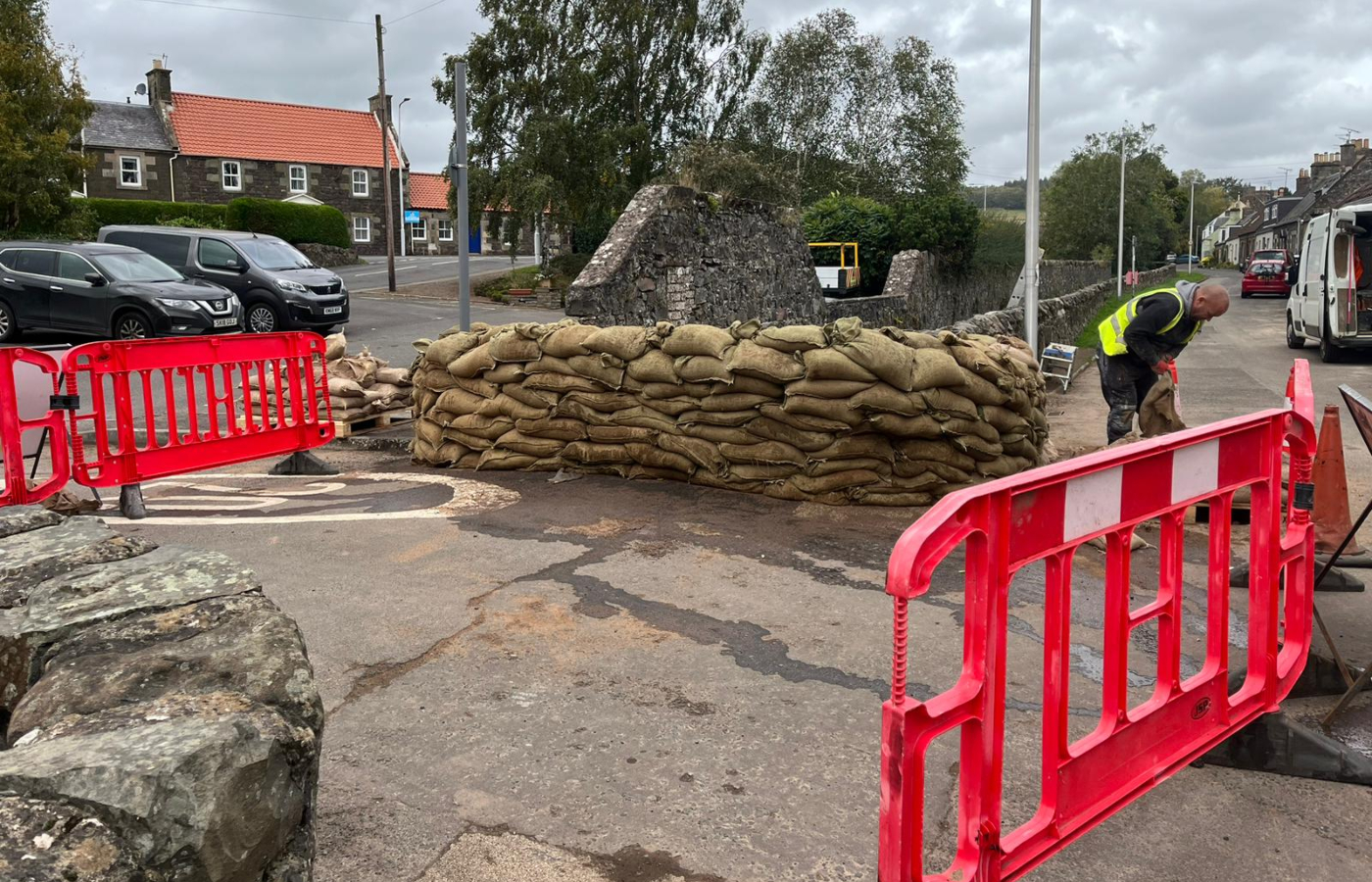
- Council runs out of sandbags before flooding begins
- 10,000 homes lose electricity in Storm Babet power cuts
A rare red weather warning has come into effect as parts of Scotland have been battered by heavy rain and extreme winds due to Storm Babet.
The Met Office extended the alert to a wider area of Scotland, which came into effect at 6pm on Thursday and is expected to be in place for around 18 hours.
Severe flooding and “danger to life” conditions are expected with multiple alerts in place across the country.
A red warning is issued only when dangerous weather is forecast and it is “very likely there will be a risk to life”.
The alert covers the north east, including parts of Angus, Aberdeenshire and Tayside.
Share your videos or pictures of the weather with STV News. Send the team a message on Facebook, Instagram or Twitter, or email at STV.News@stv.tv
@stvnews More than 300 homes in Brechin are set to be evacuated over 'life-threatening' flooding fears. #flood #storm #update #updates #news #socialnews #social #forecast #weather #reporter #rain #rainfall #emergency ♬ original sound – STV News
Ahead of the red alert, hundreds of homes in Angus were evacuated amid fears the South Esk river would burst its banks on Thursday.
Around 400 properties in Brechin were targeted with council officials going door-to-door. A rest centre opened at 3pm to offer respite while more vulnerable people were placed in hotels.
Angus Council said there were 335 homes in the town and an additional 87 homes in Tannadice and Finavon, where residents will be asked to evacuate “for their own safety,”
Meanwhile Scottish and Southern Electricity Networks (SSEN) said 10,000 homes lost electricity in power cuts caused by Storm Babet.
The energy provider said it had since restored services to 7,000 homes.
Posting on X, formerly Twitter, it said it was “working to reconnect” around 3,000 more properties.
It warned customers not to touch damaged equipment and said it had extra staff to help.
The Scottish Environment Protection Agency expects Storm Babet to break records for the most rainfall. The storm is set to bring a month’s worth of rain within 48 hours across parts of the country and locally, two months’ worth to areas of Angus and Aberdeenshire.
The red weather warning follows severe flooding in north eastern areas just days ago, with residents only just beginning to sort through their damaged belongings and some forced out of their homes for months due to water damage.
Watch
Latest update from STV weather presenter Philip Petrie
Meanwhile, a second amber warning for wind has also been issued covering the north east coast.
Police Scotland has asked drivers to consider if their journeys are really necessary. The First Minister said travel should be avoided “unless absolutely essential” in the areas on red alert.
In response to this forecast, Scottish and Southern Electricity Networks has now moved to Yellow Alert status, having already activated its contingency plans earlier in the week.
SSEN say they are “mobilising” more teams to deal with any damage to the network and subsequent faults, which may impact customers’ power supplies.
SSE has confirmed power cuts in Milltimber in Aberdeen, on the west coast of the Cowal peninsula, in Glen Spean, on the Isle of Mull and in Ardnamurchan.
Scottish Power has confirmed power cuts in Cupar and Burntisland in Fife, Bonnybridge, and Biggar.


ScotRail has suspended services between:
- Aberdeen & Elgin
- Edinburgh & Aberdeen via Fife
- Perth & Aberdeen via Dundee
- Dunblane & Perth
- Perth & Aviemore
- Tain & Wick / Thurso
- All Fife Circle services
ScotRail’s 5.17am service from Oban to Glasgow Queen Street struck a tree in the Taynuilt area.
Network Rail is on route to the scene.
The A85 near Cruachan power station was closed for over an hour in both directions due to a fallen tree.
Watch
Which parts of Scotland are set to be hit by Storm Babet?
‘Unprecedented escalation’ forecasts ‘extraordinary’ rainfall
“The Met Office have taken the unprecedented decision to escalate several weather warnings for Thursday, and in particular issue a red weather warning for rain – the first of its kind for Scotland since 2015,” said STV weather presenter Philip Petrie.
“Much of the north and east of the country will see gusts of 40-50mph, with the most severe gales occurring within the amber wind zone, around the coasts of Aberdeen, Aberdeenshire, Angus and Dundee.
Please be aware of the challenging weather we are due to experience across Scotland, most severe from Thursday 18:00 – Friday 12:00
— Humza Yousaf (@HumzaYousaf) October 18, 2023
Weather warning across Angus & the North East has been upgraded to Red.
Travel should be avoided unless absolutely essential. https://t.co/5BxasmtweE
“Thursday could see gusts in excess of 70mph at times around coasts, causing huge impacts exacerbated by prolonged heavy rainfall and the fact it is an unusual wind direction for winds of this strength.
“The red warning is where we will see extraordinary amounts of rainfall in the space of 48 hours. Some areas could see 200-250mm of rainfall within the timeframe of the storm.
“Of course anyone within the red warning area should not travel unless completely necessary, and also prepare for the likelihood of flooding, disruption and danger to life from debris caused by the accompanying strong winds.”
Where and when are the weather warnings in force?
The red alert comes into force from 6pm on Thursday until midday on Friday and covers an area along the coast north of Dundee up to Stonehaven. This has been extended into western Tayside.
A yellow warning for rain comes into force from 6am on Thursday, covering all of lowland Scotland, all of the north east, and much on the inland Highlands. This has been extended to shortly before midnight on Saturday.
A yellow warning for wind is in force from 6am on Thursday, covering most of Fife and all of the mainland north of St Andrews, as well as Shetland and Orkney. It ends at midday on Friday.
An amber warning for rain comes into force at 6am on Thursday over Perthshire, Angus and Aberdeenshire. It ends at 6pm on Friday.
A second amber warning for wind comes into force at 10am on Thursday across the north east coast. It ends at 6pm on Thursday.
An amber warning for rain has been issued across Midlothian, East Lothian and the Scottish Borders from Friday until 6am on Saturday.
Watch
Farmers race to save harvest before Storm Babet hits
First Minister Humza Yousaf warned against all but essential travel in parts of Scotland affected by the red weather warning from Storm Babet.
The Met Office said there is a “risk to life” from flooding in Aberdeenshire, Angus and parts of Tayside.
Yousaf posted on Twitter: “Please be aware of the challenging weather we are due to experience across Scotland, most severe from Thursday 6pm – Friday 12pm.
Watch
Preparations against life-threatening rain as Met Office escalates Storm Babet to red alert
“Weather warning across Angus and the north east has been upgraded to red.
“Travel should be avoided unless absolutely essential.”
He added: “The Scottish Government is working with local resilience partners, including our emergency services, to ensure we keep everyone safe and mitigate disruption as best we can.”
It comes after much of Scotland suffered widespread flooding earlier this month.
 STV News
“Exceptionally wet” conditions are expected for eastern Scotland with a “threat to life” amber warning for rain in force between 6am on Thursday and 6pm on Friday.
People have been urged to prepare if they are in an affected area.
There is concern that surface water flooding may be exacerbated by debris blocking drainage and culverts as a result of the high winds.
The warnings follow some of the heaviest rain Scotland has witnessed since the 1890s.
The RNLI has urged people to stay away from coasts and consider the dangers of the ongoing storm.
The charity said that Storm Babet poses a safety risk to those visiting the coast and is urging the public to exercise extreme caution, particularly along exposed cliffs, seafronts and piers.
Michael Avril, RNLI regional water safety lead Scotland, said: “The forecasted strong winds along with heavy rain are likely to cause very dangerous conditions on our coastlines around Scotland.
“The RNLI is advising people in Scotland to not visit the coast during this time in order to stay safe. It is a possibility that by being too close to water and cliff edges in these conditions could knock you off your feet or wash you into the sea. It is not worth risking your life.
“If you see someone else in danger in the water at the coast, call 999 and ask for the Coastguard. If inland, call 999 and ask for the appropriate emergency service. Advise them to float to live and don’t go in the water yourself – you will end up in difficulty too.”
The RNLI advice is:
• Do not visit stormy, wintery seas and cliff edges
• Follow emergency service advice around essential travel
• Please do not take risk by putting yourself, family, friends and rescue services in danger by visiting the coast
• In an emergency call 999 and ask for the emergency services
Earlier this month, parts of Scotland saw up to three weeks worth of rain fall over a short period of time, leading to businesses and homes being flooded and areas cut off due to landslips.
The body of a man swept away in the River Tay was discovered.
The country’s multi agency response team will be fully operational at the Traffic Scotland national control centre alongside the Transport Scotland resilience room to monitor conditions, respond to any major conditions, and to help co-ordinate messaging and communications.
Chief superintendent Hilary Sloan, head of road policing, said: “Our advice is to plan ahead and consider if your journey is really necessary or if it can be delayed until conditions improve.
“Stopping distances can be at least double on wet roads compared to dry conditions, and spray can reduce driver visibility.
“If you need to travel, please drive to the conditions, be prepared for delays and allow extra time for your journey.”
Follow STV News on WhatsApp
Scan the QR code on your mobile device for all the latest news from around the country