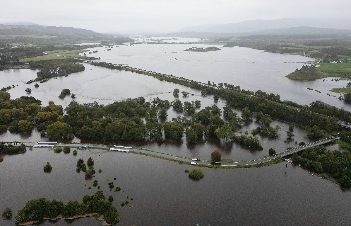
Storm Babet has been escalated with an amber weather warning for extreme rain in Scotland expected to bring life-threatening flooding.
The second named storm of the season will bring a month’s worth of rain within 48 hours. Locally, areas of Angus will see two month’s of rain in the same time.
It comes after much of Scotland suffered widespread flooding earlier this month.
 Perfect View Productions
Multiple severe weather warnings for wind and rain are in place for Thursday, Friday and Saturday.
People have been urged to prepare if they are in an affected area.
There is concern that surface water flooding may be exacerbated by debris blocking drainage and culverts as a result of the high winds.
⚠️⚠️ Amber weather warning issued ⚠️⚠️
— Met Office (@metoffice) October 17, 2023
Rain across eastern parts of Scotland
Thursday 0600 to 1800 Friday
Latest info 👉 https://t.co/QwDLMfRBfs
Stay #WeatherAware ⚠️ pic.twitter.com/3nCqMRXGpU
Gusts in excess of 60mph are possible in eastern and northern Scotland from Thursday.
It comes after much of central Scotland awoke to very foggy conditions on Tuesday morning.
There were multiple road crashes with drivers warned to take care due to reduced visibility.
The warnings follow some of the heaviest rain Scotland has witnessed since the 1890s and could hit some already saturated and flooded areas.
The country’s multi agency response team will be fully operational at the Traffic Scotland national control centre alongside the Transport Scotland resilience room to monitor conditions, respond to any major conditions, and to help co-ordinate messaging and communications.
The weekend of October 7 and 8 saw 100 to 150mm of rain falling widely across a swathe of the Southern and Central Highlands.
The current forecast rainfall amounts indicate that some areas in northeast Scotland could see 150 to 200mm of rain over a two to three day period.
The rain will be accompanied by strong east to south-easterly winds.
Stein Connelly, from Transport Scotland, said: “We recently witnessed some of the most severe weather in Scotland since the 1890s, and another wave of challenging conditions is expected this week.
“I would again ask the public to plan ahead and be prepared. Check before your travel as your journey is likely to be affected by these latest severe weather warnings – whether by foot, bike, car, rail or ferry.
“The multi agency response team will be in operation to monitor conditions and co-ordinate our response, however, the public can play a key role by delaying their journey, where appropriate.
“Latest Police Scotland advice is to expect a high risk of disruption, however, this could change over the next 24 hours, so please check the Traffic Scotland and Police Scotland social media updates and local radio bulletins for the very latest updates.”
Chief superintendent Hilary Sloan, head of road policing, said: “Our advice is to plan ahead and consider if your journey is really necessary or if it can be delayed until conditions improve.
“Stopping distances can be at least double on wet roads compared to dry conditions, and spray can reduce driver visibility.
“If you need to travel, please drive to the conditions, be prepared for delays and allow extra time for your journey.”
ScotRail’s customer operations director, Phil Campbell added: “The Met Office has issued weather warnings from Thursday through to Saturday, with an amber warning for heavy rain across eastern Scotland, and yellow warnings for heavy rain and high winds in central and northern Scotland.
“We’ll continue to monitor the forecast, and teams will be working around the clock to deal with any weather-related incidents that Storm Babet brings. Our first priority is always to ensure the safety of our staff and customers.
“We ask customers who are planning to travel to keep an eye on our website, app or social media feeds for live updates.”

Insight Philip Petrie STV weather presenter
It’s unprecedented to issue a warning so far advance, so when the yellow weather warning for rain on Thursday was issued on Sunday it gave a hint that something significant was happening.
Already we have several yellow warnings in place for heavy rain and strong winds but the Met Office has decided to escalate one of the rain warnings to amber. We are expecting some significant impacts and disruption due to flooding caused by the heavy and persistent rain across parts of Grampian, Angus, Perth and Kinross and Fife.
Potentially we could see 150-200mm of rain falling in this area, with north western parts of Angus possibly seeing as much as 250mm of rain in 48 hours.
There is a chance the Met Office could escalate the warning further, but more certainty is needed over the next 24 hours as to how much rain will actually fall.
The alert covers almost all of the country on Thursday.
A yellow warning for rain comes into force from 6am on Thursday, covering all of lowland Scotland, all of the north east, and much on the inland Highlands. It ends at 6am on Saturday.
A yellow warning for wind is in force from 6am on Thursday, covering most of Fife and all of the mainland north of St Andrews, as well as Shetland and Orkney. It ends at midday on Friday.
An amber warning for rain comes into force on 6am over Perthshire, Angus and Aberdeenshire. It ends at 6pm on Friday.
Earlier this month, parts of Scotland saw up to three weeks worth of rain fall over a short period of time, leading to businesses and homes being flooded and areas cut off due to landslips.
It comes after the body of a man swept away in the River Tay was discovered.
Power and phone lines could be impacted while motorists have been urged to take care due to dangerous driving conditions.
Public transport may be subject to delays and cancellations amid the heavy rainfall.
Follow STV News on WhatsApp
Scan the QR code on your mobile device for all the latest news from around the country


