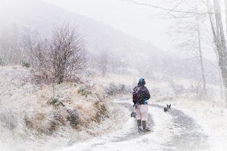
Periods of “significant” avalanche activity are being predicted in mountainous areas across Scotland.
The chance of snowslips has been estimated to range from moderate to high in all areas monitored by the Scottish Avalanche Information Service (SAIS) from Friday night into Saturday morning.
It comes as the Met Office issued a yellow warning for snow across the north west and south of the country between 3pm on Saturday and midnight.
In a statement, the SAIS said: “The SAIS service has issued a considerable to high avalanche hazard in all of its operational areas.
“This marks the start of a period of significant snowfall and challenging winter conditions.
“Overnight during Friday and the early hours of Saturday, precipitation will turn to rain at summit levels.
“A period of significant avalanche activity will take place overnight with large avalanches expected in many mountain areas.
“This should diminish by daybreak on Saturday as it turns colder.
“Later Saturday, further snowfall and gales are expected for the next days.”
Lochaber has a high risk of avalanche, Glencoe, Creag Meagaidh and the Cairngorms have considerable risk, while the chance of snowslips in Torridon have been estimated to be moderate.
Follow STV News on WhatsApp
Scan the QR code on your mobile device for all the latest news from around the country


