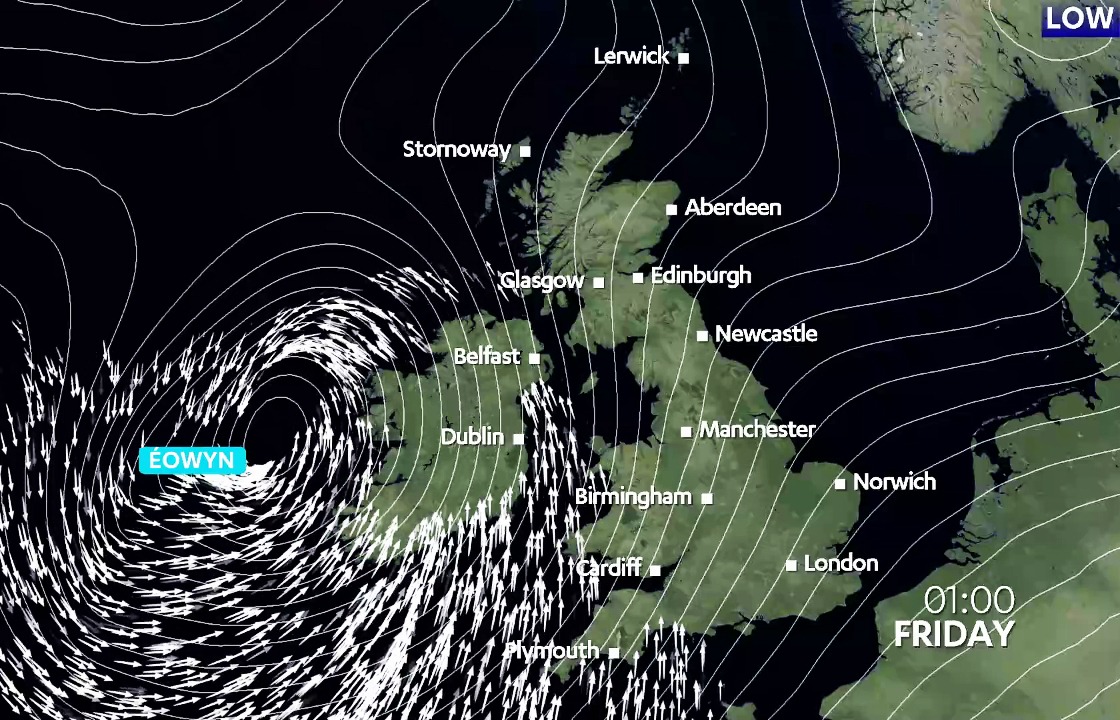
Storm Eowyn could bring the lowest pressure to Scotland since 1982, potentially making it one of the most intense storms in recent history.
While Texas, Louisiana, and Florida experience rare and historic snowfalls, these events mark the beginning of a chain reaction that will culminate in Storm Eowyn battering us on Friday.
The unusually cold conditions sweeping into the southern states are creating a significant temperature contrast in the western Atlantic.
 STV News
This contrast is supercharging the jet stream, pushing it to speeds exceeding 250mph. While this is great news for those flying back to the UK from the US – making their journey much quicker – it spells trouble for those on the ground, as it intensifies storm systems and their impacts.
The fast-moving jet stream invigorates weather systems crossing the Atlantic, causing them to intensify rapidly through a process known as explosive cyclogenesis. This occurs when a storm’s central pressure drops significantly in a short period, leading to a much more powerful system.
Eowyn is a perfect example of this, starting life rather benign over eastern Canada on Wednesday, but now hurtling its way across the Atlantic as an energetic storm system.
Extreme gusts peaking around 90mph
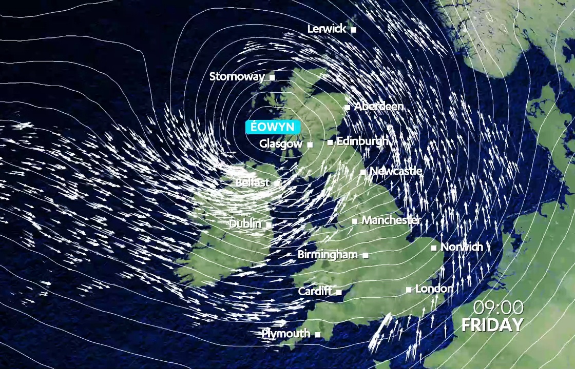
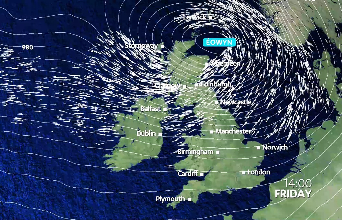
When the storm arrives on Friday, wind gusts are expected to widely reach 60-70 mph across much of the country. However, parts of the north may experience a calmer start to the day as the storm’s centre passes overhead – though winds will strengthen later.
The worst of the winds from Eowyn look as though they will hit central, southern and western areas of the country and, worryingly, the more populated areas during daylight hours when there are more people out and about.
Across Argyll and Bute, Lanarkshire, Fife, Edinburgh, the Lothians, Ayrshire, the Borders, Renfrewshire, Inverclyde, Dunbartonshire, and Glasgow, wind gusts could reach up to 80mph.
In built-up areas, this is likely to cause damage. Even more extreme gusts, peaking around 90mph, are possible in exposed locations such as islands, coastal areas, hills, and bridges.
One saving grace at least is that the peak of winds in the south west, along the Ayrshire coast looks like coming during low tide which should lower the risk of large waves coming over sea walls, although saying that winds will still be strong at high tide times too.
What should we prepare for?
With wind speeds like these, rail and ferry services are likely to face severe disruption. Some areas may experience power outages, and we can expect damage such as tiles coming off roofs and trees being uprooted. It’s a good idea to stay updated on weather warnings and secure anything outside that could be blown away.
One of the most unforgettable storms in recent years to hit central and southern Scotland was ‘Hurricane Bawbag’ (officially named Friedhelm) in December 2011.
However, just weeks later, in early January 2012, an even more powerful storm swept through central Scotland, bringing winds exceeding 100 mph to parts of Edinburgh and leaving hundreds of thousands of homes without power.
How will Éowyn compare to the monster storms of winter 2011/12?
 STV News
 STV News
One of the most intense storms in recent history
When it comes to storm intensity, we’d use central pressure to assess how powerful this storm is and ‘Bawbag’ reached a low pressure centre of 945mb over the Western Isles, the lowest pressure recorded in the UK since January 2000.
Even though the winds were stronger in the January 2012 storm, the intensity of the low wasn’t quite as strong as the one in December with a pressure recording of 952mb.
Currently, it looks like Eowyn could see pressure drop to just below 940mb close to Tiree on Friday morning, which could be the deepest storm centre recorded in the UK since a major storm in 1982 saw pressure drop to 937mb in Stornoway.
A little fact for you, if you’re in the Hebrides on Friday the kettle might actually boil a little quicker as with such low-pressure water will boil at around 96C.
The all-time record for intensity is 927mb in Perthshire, recorded in January 1884. Storm Éowyn looks at least set to be one of the most intense storm systems to sweep Scotland when it comes to pressure but may just be shy of the record.
Wind speeds
While the storm may well end up one of our most intense when it comes to pressure, wind speeds are more down to the track of storms and the geography of the areas they hit.
Gusts from Eowyn look likely to be somewhere in the region of 70-80mph in central and southern Scotland. If winds exceed 80mph, which there is a risk of, this is most likely around Islay, Kintyre, Arran and the Ayrshire and Dumfries and Galloway coast.
In the January 2012 storm, winds hit 90mph in Renfrewshire, 92mph on the Kintyre peninsula, 97mph in Tiree, and 102mph at Blackford Hill in Edinburgh.
In terms of wind speeds, it appears that Eowyn will rank below the storm of 2012. However, at the extreme end, similar gusts could still be experienced along the south and west coast.
As always, stay tuned for the latest updates as the storm develops over the coming hours. Keep an eye on any changes to weather warnings, and most importantly, stay safe.
Follow STV News on WhatsApp
Scan the QR code on your mobile device for all the latest news from around the country


