Latest updates
-
 Power cuts have left homes without power in Argyll and Bute, Perthshire, the Hebrides, Arran, and Perthshire
 - All CalMac ferries are either cancelled or facing disruption
- Several train services in the Highlands have been suspended
- Amber warning for wind to come into place at 4pm extended into Wednesday
- Storm Bram is forecast to bring gusts of up to 90mph which pose a danger to life
- Yellow warnings for wind and rain are in force across Scotland until Wednesday
- Glasgow’s Winter Wonderlands have been forced to shut
- Forth Road Bridge closed to double-deck buses, motorcycles, vehicles with trailers, cyclists and pedestrians
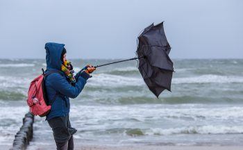
A Met Office amber weather warning has been extended, and ferries and trains have been cancelled as Storm Bram brings travel disruption to Scotland with wind gusts of up to 90mph forecast.
Weather warnings started coming into force at 6am on Tuesday. Two yellow wind warnings are in place from 12pm covering the whole of Scotland apart from Shetland.
An amber warning for wind comes into force at 4pm for the Highlands, the Western Isles, and Argyll and Bute, lasting until 3am on Wednesday. Yellow wind warnings remain in place across much of the country through to Wednesday.
Network Rail said that some train services in Scotland will be suspended due to the conditions later on Tuesday.
Rail services between Fort William and Mallaig will be suspended from 4pm and between Dingwall and Kyle of Lochalsh from 5pm due to “extreme winds”.
Speed restrictions are in place on other routes. Passengers are being urged to plan ahead.
Power cuts were reported across the HS2, FK17, and FK16 areas.
Strong winds and heavy rain brought down power lines, leaving many homes and businesses without electricity. Engineers have been deployed to assess the damage, but the duration of restoration efforts remains unknown due to hazardous conditions.
CalMac has said a number of ferry routes on the west coast are cancelled or are facing disruption.
Due to Strong Winds exceeding 50mph, the Forth Road Bridge is now closed to double-deck buses, motorcycles, vehicles with trailers, cyclists and pedestrians.
Forecasters say a deep area of low pressure passing to the west of Scotland will drive exceptionally strong southwesterly winds into western and northern areas.
Gusts of 70–80mph are widely expected, with the possibility of 90mph gusts in exposed locations.
Heavy rain is forecast to push north through the country on Tuesday morning, accompanied by a yellow rain warning across central Scotland.
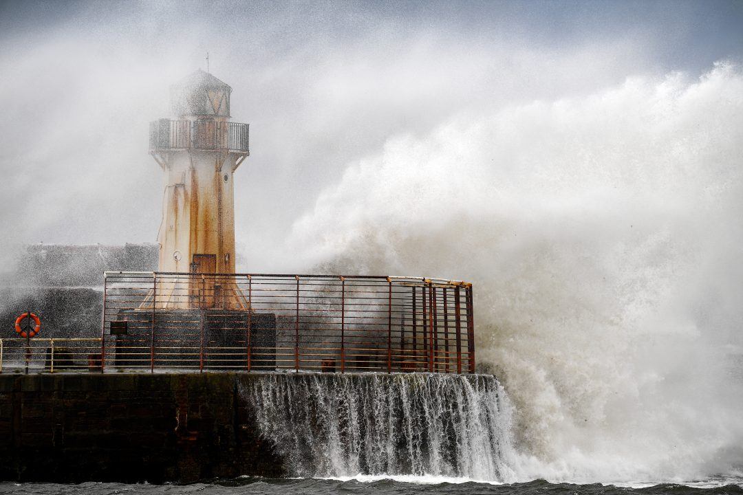
The Met Office has warned that the “disruptive” conditions could cause significant travel disruption on rail, ferry and air routes, as well as posing a risk of damage to buildings and homes.
Police have issued urgent travel advice ahead of Storm Bram, urging the public to avoid unnecessary journeys as amber-level winds hit northwest Scotland.
Drivers are told to plan ahead, carry essentials, and not ignore road closures, with high winds posing risks for HGVs, buses, and vulnerable vehicles.
The public is advised to expect major disruption, including potential route closures, poor visibility, and debris on roads.
Forecasters are warning of a danger to life from flying debris, large waves and beach material being thrown onto sea fronts, coastal roads and properties.
The public has been warned to expect delays to public transport, particularly ferries, spray and flooding on roads, as well as potential power cuts and flooding in homes and businesses.
Both of Glasgow’s Winter Wonderlands have been forced to shut as weather conditions continue to worsen.
Organisers confirmed that the festive attractions at Glasgow Green and St Enoch Square will close from 12 noon until midnight on Tuesday, 9 December, citing public safety concerns. Online bookings will be refunded, they added.
Members of the public are urged to stay safe in coastal areas and to be aware of large waves, while walkers are urged to stay back from cliffs and keep dogs on leads
To keep passengers and staff safe, Network Rail said a series of speed restrictions will come into force from Tuesday and run into Wednesday.
ScotRail service delivery director Mark Ilderton urged passengers to check their journeys before travelling.
He said: “Safety is our absolute priority, and with Storm Bram expected to bring severe weather, we’re advising customers to plan ahead and check their journey before setting off.
“Speed restrictions will be in place across parts of the network, and while this may mean some journeys take a little longer, these steps are essential to keeping everyone safe.”
Cabinet secretary for transport Fiona Hyslop said: “Storm Bram will be the second named storm of the season, bringing challenging weather conditions and a period of disruption to the transport network.
“The Met Office warnings show high winds will impact the whole country, particularly in parts of the North West and Western Isles covered by the amber warning, so it’s vital people plan ahead if they have to travel.
“The Traffic Scotland website offers the latest information on the trunk road network and also has details of ‘wind based’ closures for the bridges. The Traffic Scotland X page is also updated regularly. I’d urge motorists to check their routes before setting off as the conditions will bring challenges for drivers.
“The high winds are likely to impact other modes of transport, so if you are planning to travel by train, ferry or air, please check with your operator to see if your service has been affected.”
Comhairle Nan Eilean Siar confirmed that all school and integrated Uist buses will be cancelled, although schools are expected to remain open.
Insight Jo Farrow STV News weather forecaster
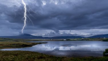
Scotland is stuck in a mild but wet and windy Atlantic flow this week. There have been bouts of heavy rain moving north-eastwards adding to rivers and puddles but also after the recent “Super” full moon there have been high spring tides and coastal flooding.
Next will be Storm Bram midweek, which has been named by Met Éireann, the Irish Meteorological Service which will bring more heavy rain on Tuesday morning.
This is the second named storm from the western naming group of UK, Ireland and the Met Office. Storm Amy was early in October and we have also seen Claudia which brought heavy rain to the UK. Claudia was named by the Spanish Met Service in a different southwest naming group.
Bram (as in Abraham) looks set to bring heavy rain from the south early on Tuesday. Much of mainland Scotland will see a grim Tuesday morning with heavy rain and blustery winds although it will feel strangely mild in this southerly flow. Don’t be fooled in northern Scotland early on Tuesday where there will be a calmer, drier start. The weather will deteriorate especially for the Western Isles.
Depending on the track of the windstorm it looks like the west coast of Ireland will see wild conditions by day and these should reach the west coast of Scotland by Tuesday afternoon.
The storm will then rage through Tuesday night for western Scotland with an Amber wind warning for the Western Isles. The wild weather will continue into Wednesday morning for the northwest and north of Scotland, particularly for the Islands. with a windy day across the mainland.
The winds will ease down as the storm slowly eases away northwards towards western Norway but it will take until Friday for calmer weather to arrive for Scotland.
A strong Jetstream across the Atlantic is directing low pressures our way and helping to deepen some of them. There has been cold air over North America which bought snow to Washington on Friday as the World Cup fixtures were being announced. There is still milder air over the mid-Atlantic and the stark temperature contrast helps strengthen the jet at this time of year.
Storm Bram will deepen rapidly on Tuesday as it moves northwards past western Ireland and then western Scotland. The Inshore Waters forecast from the Met Office mentions Severe gale force 9 winds, up to Storm force 10, even violent storm force 11 around The Minch with very rough, even high seas. Expect ferry disruption.
Follow STV News on WhatsApp
Scan the QR code on your mobile device for all the latest news from around the country