Latest updates
-
 Major roads have been flooded as heavy rain batters Scotland
 - Three rescued from flooded vehicles in Kintore and Banchory
- Cows were forced to flee their field after it became submerged in water
- Drivers urged to move their cars from next to River Dee due to high tide
- 27 flood warnings in place by SEPA amid seven amber alerts
Major roads have been flooded as parts of Scotland are being battered by 18 hours of heavy rain amid an amber weather warning.
The Met Office issued the alert from midnight on Thursday until 6pm in Angus, Perth and Kinross, and Aberdeenshire.
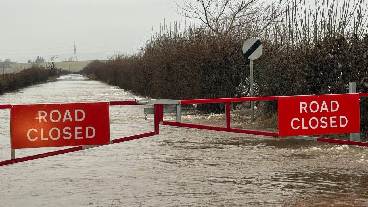
The deluge has already caused significant disruption in the region, with a section of the A90 being closed due to flooding. This has left the rural hamlet of Bogindollo cut off.
The A9 south of Ballinluig and the A85 between St Fillans and Lochearnhead have also been flooded.
 Debs Lamb
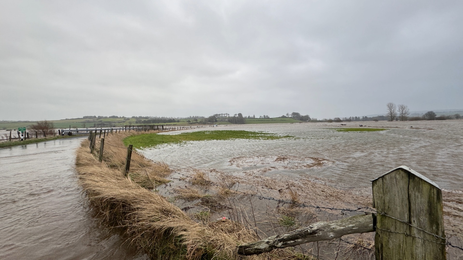 STV News
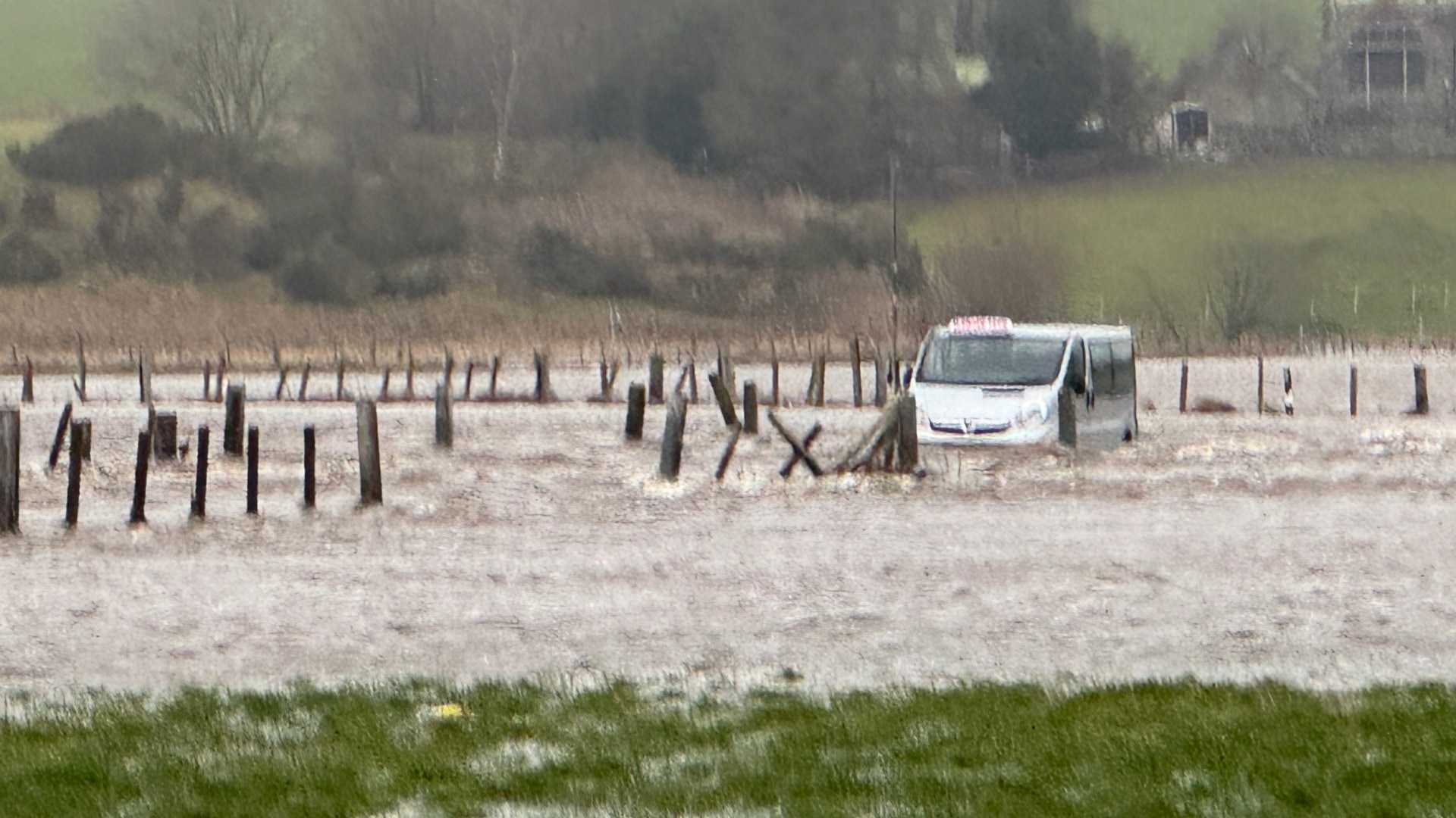 STV News
Footage shared on social media showed no access on the road to Banchory from Cairn O’Mount due to deep flooding.
BEAR NW Trunk Roads shared images of the “sheer volume of water” from the hillside next to the A85 between Crieff and Lochearnhead.
The road is said to be passable with care.
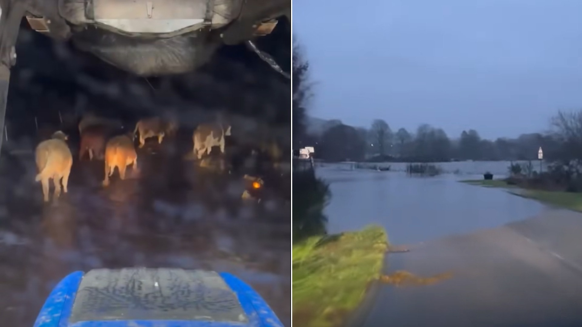
Aberdeen City Council urged people who have parked vehicles in the Riverside Drive area beside the River Dee near Bon Accord Glass to move them as soon as possible.
“Flooding is expected on the road between Duthie Park and the junction of Riverside Drive and South College Street.
“The nearby flood gates have been closed and they will remain closed until tomorrow at least,” a statement read.
SEPA has issued 27 flood warnings across much of the north and seven amber alerts.
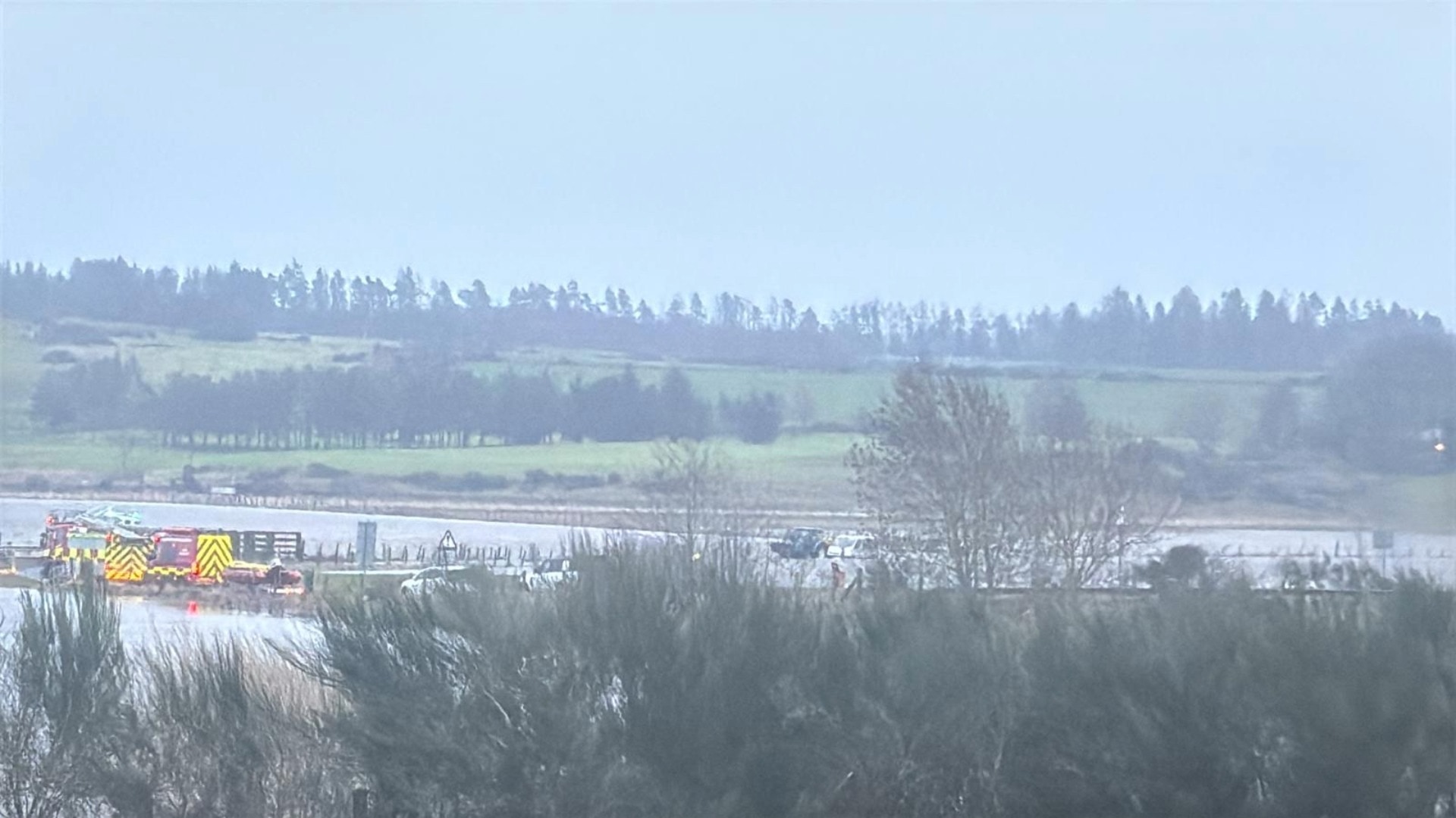
Two people were rescued from a minibus stuck in flood water on the B977 outside Kintore in Aberdeenshire on Thursday morning.
Fire crews deployed specialist water rescue units to the scene.
In a separate incident at around the same time near Banchory, one person was rescued from a car.
The spokesperson added: “We were alerted at 8.32am on Thursday to reports of a vehicle in flood water near the B976 in Banchory, Aberdeenshire.
“Operations control mobilised two fire appliances and specialist water rescue units to the area.
“One casualty was removed from the car and guided to a place of safety. They were then checked over at the scene by the Scottish Ambulance Service.”
The River Dee is rising quickly, with one clip showing cows fleeing their submerged field in deep water. The banks of the River Don are also experiencing fast flowing water.
Network Rail has confirmed that speed restrictions have been put in place on a number of routes across the country, including the Inverness-Aberdeen route, to ensure passenger safety.
 Fubar News
ScotRail confirmed a number of services from Inverness to Edinburgh will terminate early at Perth.
First Minister John Swinney said on X: “Weather conditions in Perthshire are very challenging just now. Some roads are closed and the flooding danger is higher.
“Please be careful and follow advice.”
The Met Office has warned that fast-flowing or deep floodwater is likely, posing a danger to life and disruption on road, rail, air and ferry routes.
Spray and flooding are likely to create difficult driving conditions, with road closures expected. Communities may also become cut off by flooding.

Rain will be persistent and heavy on Thursday, with widespread accumulations of 60-80 mm likely and as much as 100-120 mm over high ground. Rainfall may even exceed 150 mm in a few places.
On high ground, rain will fall as snow.
The warning read: “This is expected to lead to some surface water and river flooding across the area.
“This amber warning indicates where there is a greater likelihood of medium-level impacts due to mainly river flooding, with the yellow warning covering a wider area and longer time period.”
A yellow rain alert for Tayside, Fife, Grampian and the Highlands comes into effect at 6pm on Wednesday and will run until shortly before midnight on Friday.
Between 30 and 60mm of rainfall is likely to fall inland, with as much as 80-120 mm possible over high ground.
Drivers have been warned to take care, and the Met Office also said power cuts are possible due to adverse weather.

The Scottish Environment Protection Agency has issued three flood alerts for Churchill Barriers in Orkney, Finavon and Tannadice, and Kinnard/Bridge of Don in Dundee and Angus.
Six further amber flood alerts have been issued for parts of the north east and central Scotland.
ScotRail has speed restrictions in place for its Perth to Inverness route from 6pm on Wednesday until 9.30am on Saturday, and its Aberdeen to Inverness routes from 12.01am on Thursday until 12pm on Friday.
Meanwhile, ferry operator CalMac has cancelled all of its Oban-Coll-Tiree services on Thursday, and says some of its other services may be subject to cancellations or delays at short notice, due to adverse weather conditions.
Areas impacted by yellow weather warning:
- Angus
- Dundee
- Fife
- Perth and Kinross
- Stirling
- Aberdeen
- Aberdeenshire
- Moray
- Highland
Wintry conditions to return
The significant rainfall could be followed by a plummet in temperature from around Burns Day, bringing a renewed risk of icy conditions and snow that could persist into February.
The cold spell at the start of January arrived from the north, but this time the air looks set to come from the east, which can often be even colder.

Insight Sean Batty STV weather presenter
I know whenever I write stories like this, some people respond with “it’s just winter,” and of course, that’s true.
However, it’s been several years since we’ve experienced such a prolonged period of colder-than-average conditions, and it’s relatively rare to see two notable cold spells within the same month.
The kind of conditions we’ve seen this January are now around half as likely as they would have been in the past.
Long-range forecasting is about identifying trends across many computer models rather than focusing on any single outcome.
Some runs show sub-zero daytime temperatures and lows of around –8C in Glasgow by the end of January, while others point to much milder conditions, with highs near 8C and lows of 6C.
This widespread is exactly why caution is needed when looking more than a week ahead.
However, when those extremes are stripped out, the overall trend indicates a noticeable drop in temperatures over the coming week.
This is also why claims circulating on social media about specific conditions weeks in advance should be taken with a very large pinch of salt – they usually rely on cherry-picking one model from many possible scenarios.
Another unusual feature is the presence of high-pressure systems over Scandinavia, something that has been far less common in recent winters but was a more familiar pattern during the 1980s.
I’ve just returned from a conference in Andorra, where one of the speakers was Dr Paul Williams from the University of Reading.
He discussed how the jet stream is changing in a warming world, with evidence suggesting it may be slowing and becoming more meandering at lower levels.
This can encourage more “blocking” patterns in the atmosphere – the setups that can bring colder spells in winters and hotter conditions in summers.
It’s important to stress, though, that even when we talk about colder conditions today, they tend not to be as severe as those experienced a few decades ago, because global temperatures overall have risen.
Follow STV News on WhatsApp
Scan the QR code on your mobile device for all the latest news from around the country