Scotland is set to be battered with more heavy rain on Monday as another flood warning is issued for large parts of the country.
Heavy, occasionally thundery, slow moving showers are forecast throughout the afternoon and evening over central and western Scotland.
The Met Office has warned that homes and businesses could face further flooding following a weekend of torrential rain storms.
The conditions, thought to be confined to the north west by later on in the evening, could also potentially cause travel disruptions.
The latest yellow warning is active from 11am until midnight on Monday.
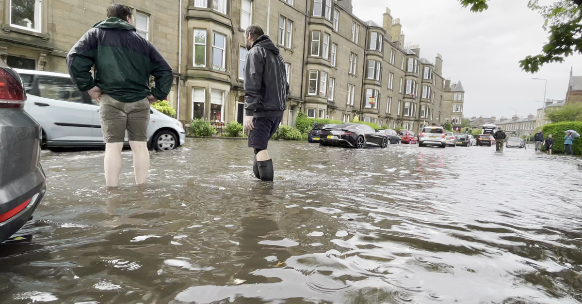
A clean up is still under way in areas battered by the worst of the weekend’s rainstorms.
Edinburgh was among the worst affected areas with 52.4mm of rainfall recorded during the storms that were sparked by warm temperatures throughout the country.
Rainwater poured into the brand new St James Quarter shopping centre through the ceiling forcing shoppers to take cover where they could.
And workers and customers were forced to wade through the Princes Street Boots store after the flood took hold.
A video posted to Facebook on Sunday showed several items from the shop’s shelves floating in ankle deep water.
Edinburgh Botanics weather station recorded 40.6mm of rain in less that one hour which led to the flash flooding.
The A720 was closed in both directions at Dreghorn and trains in and out of Edinburgh were cancelled.
A yellow weather warning for rain was issued at 6am on Saturday and remained active until midnight on Sunday.
STV Weather Reporter Philip Petrie says flooding is expected continue today with roads retaining a lot of surface water.
He said: “Over the weekend we saw a lot of wet and miserable conditions, we had a thunderstorm warning in force, flash flooding and surface water on a lot of roads – and this will continue today for many areas.
“Yesterday temperatures reached a high of 24.1c at Achnagart, and it was the warmth and humidity in the air that sparked off the thunderstorms and the heavy rain that affected particularly parts of Edinburgh, Fife and Dundee. In total Edinburgh recorded a maximum rainfall amount for the entire country of 52.4mm, and recorded 40.6mm in under one hour.”
Philip expects the conditions to last until around Thursday when it should start to dry up, although heavy rain could return by the weekend.
He continued: “Unfortunately the unsettled weather looks set to continue until midweek, with a deep area of Low Pressure moving into southern England today, that will spread northwards overnight affecting Scotland on Tuesday – further rain and strong winds throughout the day particularly across eastern areas where we have already seen a lot of rain over the past 48 hours.
“Come Thursday we do get a brief respite as a weak ridge of High Pressure builds – this will mean things turn drier for a time, still the chance of one or two showers, but come the weekend there’s the potential for further unsettled weather.”
Follow STV News on WhatsApp
Scan the QR code on your mobile device for all the latest news from around the country