Latest updates
-
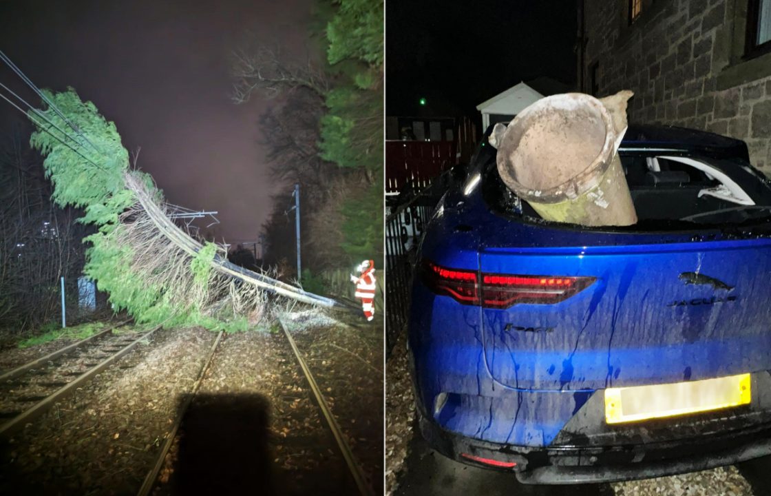
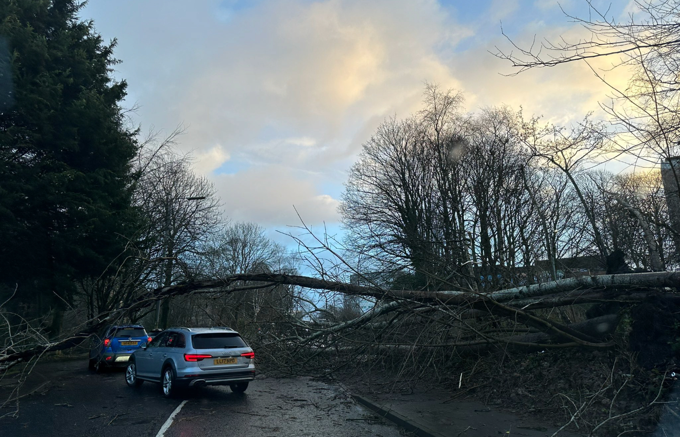
 A man has died after car crashes into fallen tree in Falkirk
 - 800 homes are without power across Scotland
- Winds of 111mph recorded in Ben Nevis
- Fresh weather alerts as Scotland to be hit by Storm Jocelyn
- All rail services have been suspended and there is widespread disruption on roads
- Passengers stranded in airports due to disruption
- Rail services across Scotland will be suspended for second time in three day
- First Minister paid tribute to the first victim of Storm Isha
A man has died after a car crashed into a fallen tree as Storm Isha wreaks havoc across Scotland with extreme winds leaving tens of thousands of homes without power.
At around 11.45pm on Sunday, a Hyundai car hit a fallen tree on the A905, Beancross Road in Grangemouth.
Emergency services attended, however the front seat passenger, an 84-year-old man, was pronounced dead at the scene.
Due to the amount of debris, short notice road closures, localised flooding and other issues are expected, in addition to the high winds, police said.
Watch
Winds tear roof from block of flats
 Ian Bremner
Police Scotland is advising all road users to exercise extra caution due to the disruption caused by Storm Isha overnight.
Late on Sunday evening, the Met Office issued the rare red alert for parts of Caithness, Easter Ross, Aberdeenshire and Moray.


It is only the fifth-ever red alert for wind, with previous warnings issued in December 2011, January 2012, January 2016 and November 2021.
Forecasters have warned there is a “danger to life” amid flying debris, with large waves expected in coastal areas.
The highest wind speed was recorded at Aonach Mor near Ben Nevis at a whopping 111mph, while the low-lying top speed of 107.8mph was recorded at Tay Bridge.
 Abdul Bostani
Now a newly-named Storm Jocelyn is set to arrive on Tuesday and Wednesday from Northern Ireland, with northern Scotland to see more wet and windy conditions.
First Minister Humza Yousaf paid tribute to the first victim of Storm Isha as he warned of more disruption due to the amber weather warning for Storm Jocelyn.
He said: “Tragically, Storm Isha has led to lives being lost and I send my sincere condolences to the families affected.
“The strong winds and heavy rain have impacted communities across Scotland. I want to thank all those who have worked throughout the night to keep the public safe and restore normality. But the exceptional weather conditions are not over.
“Storm Jocelyn is likely to cause more disruption, with strong winds buffeting infrastructure and rain falling on already saturated ground. Travel is likely to be difficult, particularly heading into Wednesday’s rush hour, so I urge everyone to follow guidance from Police Scotland and check updates from transport providers, Transport Scotland and the Met Office.”
Met Office Chief Meteorologist, Steve Willington, said: “Although this system will be a step down relative to Storm Isha, with the damage and clean up still underway, we could potentially see more impacts from Storm Jocelyn.

“Outbreaks of heavy rain on Tuesday could bring rainfall accumulations of 15 to 20 mm quite widely with 40 to 50 mm over higher ground in southwest Scotland, the Scottish Highlands and parts of northwest England.
 Network Rail
“Wind gusts are expected to reach 55 to 65 mph across northwestern Scotland while there is potential for winds to gust to 75 to 80 mph in a few places, in particular exposed parts of the Western Isles and coastal northwest Scotland early on Wednesday morning.”
Power could be disrupted due to the extremely strong winds, with around 100 unplanned outages reported in the early hours of Monday morning.
Around 800 properties are without power across their network but that as of 5pm on Monday, service had been restored to around 36,000 customers.
SSEN anticipates being able to connect all but around 600 customers by the end of the evening. Due to the nature of the damage caused by the storm, and the challenges getting to faults because of fallen trees and road closures, full network restoration is not going to be possible for all customers tonight.
Customers on SSEN’s Priority Services Register have been offered alternative accommodation if they are likely to be without power overnight; people on the Register can claim reasonable costs for alternative accommodation if it is expected they will be without power for over 24 hours.
Andy Smith, operations director at SSEN Distribution, said: “I would like to thank customers for their patience on what has been a challenging day in the wake of a very severe storm. Right through last night and all day today, our teams have been working hard to keep people connected. They’ve been switching the network, carrying out repairs, answering customers’ queries and offering help and support. I would like to thank them, and colleagues from our contract partners, for their hard work in response to Storm Isha.
“Our priority tonight is getting as many people as possible reconnected by the end of the evening, and doing all we can to support those customers who will still be without power overnight.

“I’d like to remind people they can call on our power cut helpline on 105 at any time for help, advice, and support.
“Another named storm – Storm Jocelyn – is expected to cause disruption tomorrow, so we’re watching its path carefully and we are ready to respond to any issues it might cause on our network through Tuesday and Wednesday.”
 Network Rail
A spokesperson for SP Energy Networks said: “As Storm Isha continues to batter our network region – where we saw winds of more than 80 mph in places – our engineers are working around the clock to ensure customers affected by power cuts are restored as quickly and safely as possible.
“The storm has affected 53,881 of our customers across central and southern Scotland, with power restored to 42,151 customers so far. 11,730 customers are currently without power and our engineers are doing everything they can – in challenging conditions – to restore supplies quickly and safely.
“Safety remains our number one priority and while high winds in some areas are making it unsafe to work at height, we continue to use every available resource to get everyone back on supply at the earliest opportunity.”

It comes as ScotRail cancelled all services from 7pm on Sunday amid Storm Isha, the ninth named storm since the naming season began in September, and the second of 2024 after Storm Henk at the start of January.
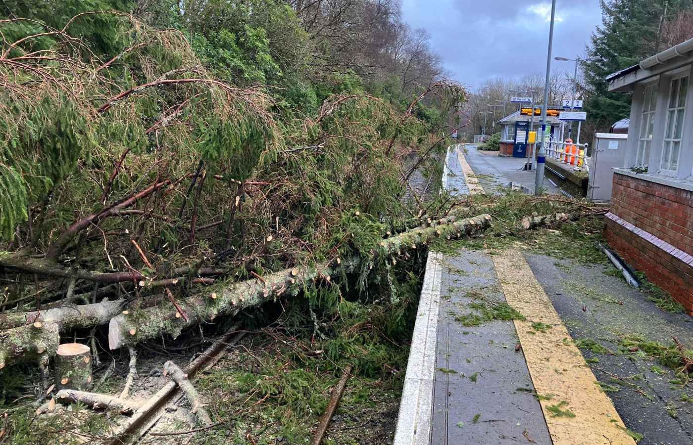
Network Rail say it will be a “challenge” to reopen Scotland’s network after damage was done to multiple lines across the country.
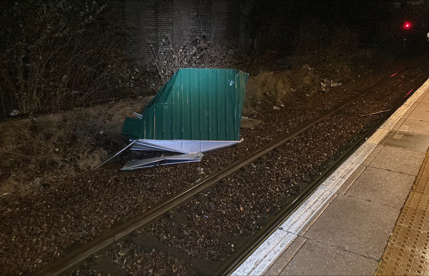
A fence blew on to the railway at Glasgow Queen Street with a boundary wall causing damage to the line with the operating expecting repairs to last several hours.
 Network Rail
At least ten trees had fallen on to the track between Easterhouse and Garrowhill with “signifcant damage” done to overhead lines.
Network Rail teams were forced to tackle the issue in the morning due to repairs requiring several hours of work, according to the operator.
The remains of a garden shed made its way on to the line in Bellgrove with Network Rail urging members of the public to keep their garden furniture – including trampolines – tied down.
Two large bins made their way on to the tracks at Inverurie with teams working to remove them blocking the line.
A fallen tree at East Linton on the mainline south of Edinburgh caused damage to overhead wires with Network Rail “working on a plan” to repair the issue.
The West Highland Line was affected by a massive tree covering the tracks between Arrochar and Tarbet as teams raced to clear the line.
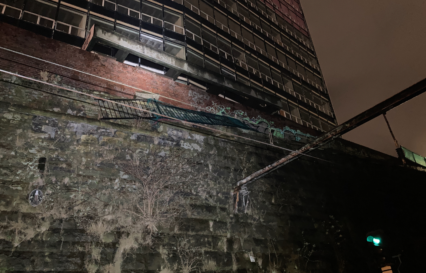
At Priesthill and Darnley, a fence surrounding the station was almost blown off as Storm Isha dealt significant damage.
A spokesperson for Network Rail said: “Thanks for your patience today if you’ve been waiting for your rail route to reopen, we know it’s a pain if your train isn’t running.
“We’re working flat out to inspect routes, clear debris and repair damage caused by Storm Isha
“You’ll have seen on our timeline the progress we’ve made so far in reopening routes. That’s all down to the hard work of our teams, which we’re grateful for.
“That will continue for the rest of the day. You may be aware that Storm Jocelyn has now been named…and it’s arriving tomorrow.
“We’re meeting this afternoon to discuss this across the industry in Scotland. Our weather specialists will give an update on the forecast and our control team will consider our response. We’ll share more when we have it.”

ScotRail also announced that rail services across Scotland will be suspended from 7pm on Tuesday amid extreme weather as Storm Jocelyn sweeps the country.
It will be the second time in three nights rail services have been stopped due to extreme weather conditions.
Additionally there will be no rush hour services on Wednesday morning.
A fallen tree on Kelvindale Road in Glasgow is said to be causing “minor” disruption to traffic with emergency services deployed to clean up the debris.
Calmac has also cancelled a number of services across the weekend with more expected.
The Corran Ferry has cancelled all their services as of 4.50pm on Sunday evening due as weather conditions continue to get worse.
Flights to and from Edinburgh and Glasgow airports have been disrupted due to the weather.
The chaotic conditions are set to continue into Tuesday and Wednesday when yellow weather warnings for wind are set to come into place.
The Met Office alert currently covers the whole of Scotland except the Shetland Islands and will come into force around 4pm on Tuesday until 12pm on Wednesday.
The warnings come after a week of arctic conditions throughout Scotland which has seen the closure of multiple schools.
Loudoun Academy in East Ayrshire was forced to close due to no electricity as a result of a power outage.
Students due to sit preliminary examinations will be rescheduled to Monday, January 29, a message to parents read.
Amid the snowy conditions people in the northern Highlands, Orkney and Shetland have been urged not to travel amid “extremely challenging” road conditions.
A man in his 60s was killed in Northern Ireland in a crash involving two vans and a fallen tree at the height of Storm Isha.
The crash happened in Limavady, Co Londonderry on Sunday as high winds battered the island of Ireland.
The man who died was driving a van that hit the fallen tree and another van on the Broad Road at around 9.45pm. The male driver of the second vehicle was taken to hospital for treatment.
South of the border two people died in road crashes when weather warnings were in place, but gardai have not said whether the storm conditions were the main contributory factor in those crashes.
A man in his 40s died in a single-vehicle crash in Claremorris, Co Mayo at about 6.15pm on Sunday when a status red alert was in place, and while a woman in her 20s, who was a passenger in a van, died after it hit a tree in Carnalogue, Co Louth at 1.50am on Monday.

Insight Sean Batty STV meteorologist
Red warnings for any weather conditions are extremely rare and should be taken very seriously as they are not issued lightly.
Computer models have been indicating wind gusts from Storm Isha of 80-90mph and this is already coming to fruition with a gust a few hours ago of 84mph close to the M8 in Salsburgh, just west of Shotts.
Latest model runs have shown an increased threat of even stronger winds travelling across the country in the coming hours with a risk that some spots in the north and north east of the country could take the sting in the tail from this storm with gusts of around 100mph.
While gusts over mountains will on quite a few occasions get gusts of over 100mph, seeing winds of this level in low-lying areas is very rare and that’s why there is concern, especially given that more built up and populated areas are at risk of these gusts.
Places such as Wick, Thurso, Dornoch, Helmsdale, Tain, Cromarty, Nairn, Forres, Elgin, Buckie, Banff, Keith, Huntly, Turriff, Peterhead and Fraserburgh are all within this red warning region.
The last time we had winds of this magnitude in January was in 2015 when the north Highlands had winds around 100mph. Loch Glascarnoch hit 111mph during that storm.
The last time Kinloss recorded winds over 80mph in January was in 1995, although just along the coast in Lossiemouth we had a gust of 87mph recorded in 2005.
Luckily the wind peak in the north comes around low tide, or the rising tide, as opposed to peak tide when coastal flooding would be more likely. That being said, such strong winds could still lead to large waves on the coasts and obviously could be very damaging.
As with all red warnings, you should stay at home and do not travel unless you absolutely have to. These sort of conditions can lead to flying debris with a risk to life.
Winds remain strong but do slowly ease on Monday before another storm system rolls in on Tuesday.
Follow STV News on WhatsApp
Scan the QR code on your mobile device for all the latest news from around the country