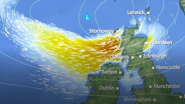
Heavy rain and winds reaching up to 60mph are expected to hit parts of Scotland from Friday.
Travel disruptions are expected for many over the weekend with possible restrictions on high-sided vehicles crossing bridges.
Ferry schedules to and from the islands could be affected.
After a warmer than average mid to end September, weather conditions are returning back to normal for the start of October.
Temperatures, which were reaching low 20s for parts of the country last week, are starting to dip again with some areas experiencing freezing conditions and light snowfall.
Friday is forecast to be a windy day, particularly in the Highlands Hebrides where gales will reach up to between 40-50mph.
Then on Saturday, much of the east coast and Northern Isles will be battered by heavy rain fall and Sunday will bring gale force winds to the Border, East Lothian, east Fife, Angus and Aberdeenshire coasts, reaching up to 50mph in Moray.
But the strongest winds will arrive on Sunday in Shetland and Orkney where they could potentially hit 60mph.
STV’s meteorologist Sean Batty said: “After a largely warm September the mercury has certainly taken a tumble in recent days with what feels like a sudden switch to autumn weather, actually just the way it should be, but it’s still a bit of a shock.
“Temperatures last week were still hitting the low 20s, which is way above the average for this time of year – around 14C.
“This week we’ve seen overnight temperatures dip briefly below freezing in the north Highlands and also some snowfall on our Munro peaks. We’re also entering a much more unsettled phase in the coming days with gales and heavy rain at times, and this could lead to disruption to ferry schedules and the possibility of restrictions being imposed on high sided vehicles on our bridges.
“Friday will be one of our windiest days with gales widely down the Highland coast and across the Hebrides, where gusts could be around 40-50mph.
“Rough seas could disrupt ferry travel to and from the islands.
“The next system I’m keeping an eye on is expected to move up from England on Saturday night and bring heavy rain to much of the country, with the strongest winds running up the east coast this time, and into the Northern Isles.
“Gusts along the Border, East Lothian, east Fife, Angus and Aberdeenshire coasts could be around 40mph on Sunday morning, and perhaps 50mph on the Moray coast.
“The strongest winds will affect Shetland and Orkney later on Sunday where gusts could peak around 60mph.
“Again this could lead to ferry disruption, but this time to and from the Northern Isles.
“While this is nothing out of the ordinary as we move into October, but it will be quite a change from what we’ve become used to in the last several months.”
Follow STV News on WhatsApp
Scan the QR code on your mobile device for all the latest news from around the country