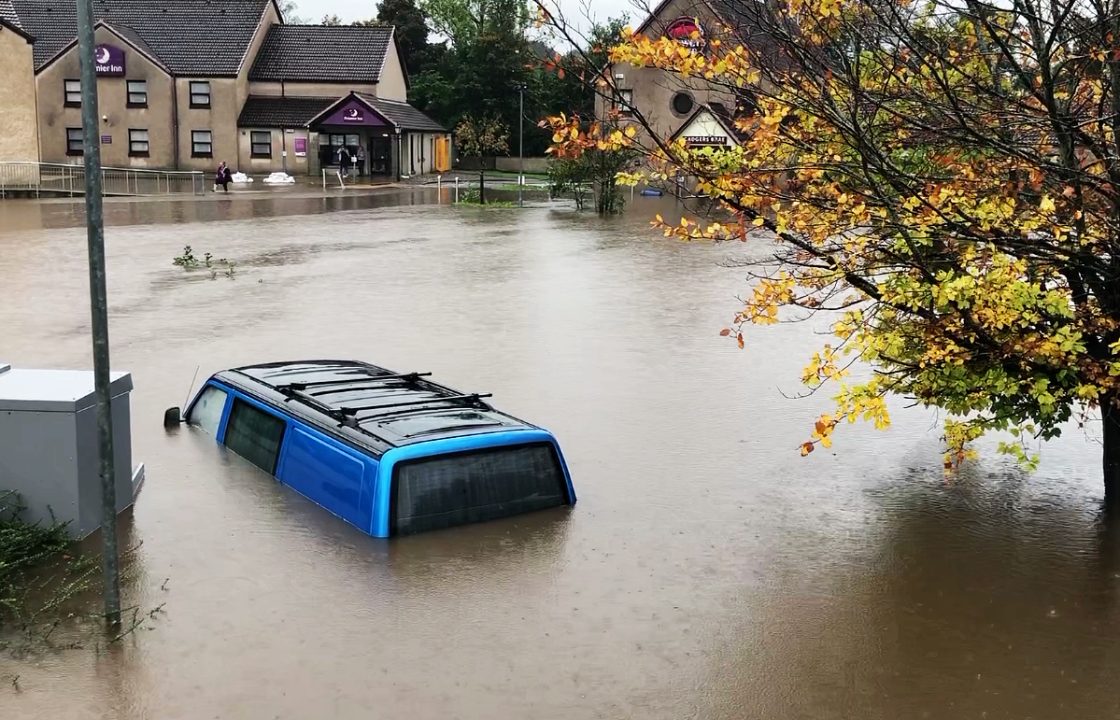
Much of Scotland remains at risk of flooding following a weekend of heavy rainfall across the country.
While no weather warnings are in place, river levels are continuing to rise and the ground is saturated, increasing the risk of flooding.
Over the weekend, the Met Office issued a fresh amber warning between 9pm on Saturday October 7 and 2pm on Sunday covering parts of Angus, Perth and Kinross, Aberdeenshire, Moray and Highland, while another yellow warning was in place covering much of north and eastern Scotland until 7pm.
A further yellow warning for rain has been issued for parts of western Scotland for Tuesday.
At 6am on Monday, October 9, two severe flood warnings were still in place for parts of Perth and Aviemore.
The warning covered the North Inch area of Perth and the Dalfaber area of Aviemore.
Basements and properties in low-lying areas of North Inch were at risk of flooding, the Scottish Environment Protection Agency (Sepa) said
The Aviemore warning covers Dalfaber Road, Inverdruie, The Old Bridge Inn, Speyside Leisure Park and the sewage treatment works.
There were also 52 flood warnings in place covering the majority of Scotland and eight flood alerts.
Despite major disruption to transport across the weekend, ScotRail said it was expecting to run a full service across most of the network on Monday morning including the central belt.
However, service delivery manager David Simpson said routes from Stirling to Perth and from Perth to Inverness were still affected by floodwater.
The Stonehaven to Arbroath route is also awaiting the completion of safety inspections, he added.
The greatest risk to a normal restart for ScotRail on Monday is on the Highland Main Line and the Perthshire areas where floodwaters remain high, so passengers whose journey runs between Perth and Inverness or Perth and Stirling are urged to check before leaving home.
In an update on Sunday, Mr Simpson said: “The weather we have seen over the weekend has been extreme and in some parts of the country we are continuing to see dangerous levels of rainfall and flooding. We appreciate that weather related disruption like this can be frustrating, but our first priority has to be the safety of the public and our colleagues.
“Our staff across the country, alongside colleagues at Network Rail, are working hard to get services back to normal as quickly and safely as possible, with the priority being getting things back to normal for Monday morning.
“Customers are advised that they should check their journey before travelling, and keep an eye on our website, app, or social media feeds for live updates.”
Apart from the two severe weather warnings, Sepa had 52 flood warnings and eight flood alerts were still in place at 6am on Monday.
Record-breaking rain hit parts of Scotland causing widespread flooding and multiple landslides over the weekend causing major disruption.
STV’s Sean Batty estimated the western side of Scotland, from northern Argyll to South Ayrshire, had around two weeks’ worth of rainfall – with one of the wettest places around Loch Restil and Rest & be Thankful with 125mm of rain falling.
A typical level of rainfall would be 350mm for the whole month of October.
Melfort, south of Oban, was the wettest spot, with 132mm of rainfall.
The village of Lochwinnoch had around 13 days worth of rain, totalling around 63mm by around 5pm on Saturday.
Further up the hill in Clyde Muirshiel, there was slightly more with 75mm recorded.
At Polmont near Grangemouth – one of the worst-hit areas of flooding – there was 50mm of rainfall; equivalent to around 17 days worth of rain for this part of the country.
 Traffic Scotland
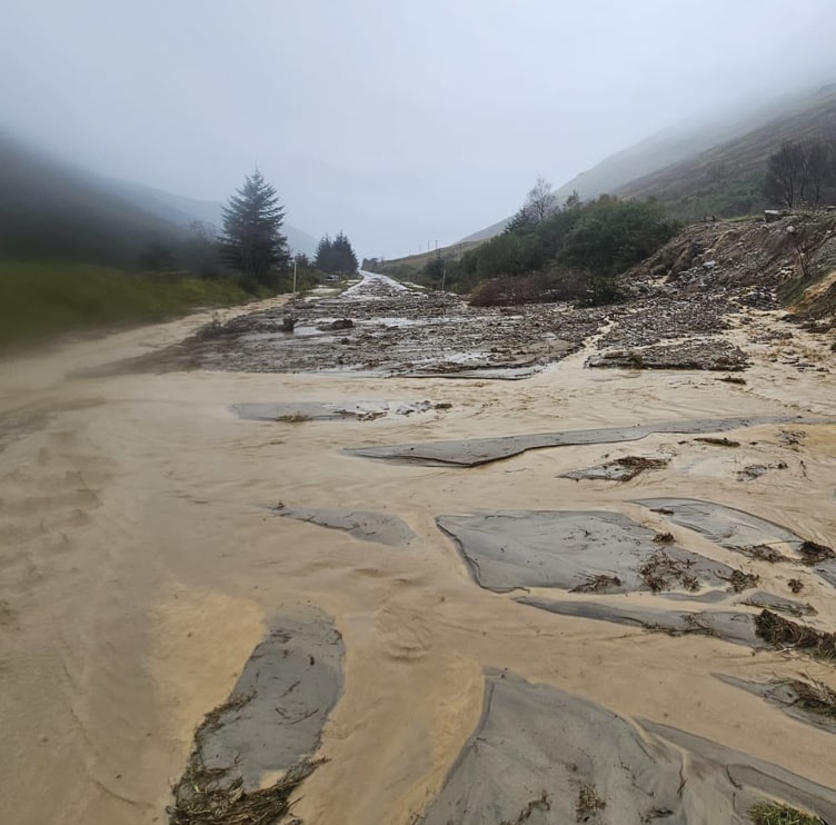
Ten people were airlifted to safety by the Coastguard after torrential rain caused multiple landslides in Argyll and Bute.
The landslips occurred on the A83 between Tarbet and Lochgilphead and on the A815.
There are no reported casualties although several vehicles were left stuck.
Footage captured by motorist Sarah Hunt-Smith showed the mud and debris spilling across the road. She was forced to turn back after the landslip swamped the carriageway just metres from her car on Saturday.
An aerial image of a landslip at Rest and Be Thankful was also shared by the Coastguard.
On Sunday, The Scottish Government held crisis talks for the second day to plan support for communities vulnerable to flooding.
Police Scotland said communities “faced some of the most challenging conditions ever, while comparisons were drawn with the Beast from the East, a cold snap in February 2018 which caused chaos in Scotland.
Ruth Ellis, SEPA flood duty manager, said: “It’s been a difficult weekend across Scotland, with severe weather causing widespread travel disruption to road and rail networks, and impacts in communities all over Scotland.
“Across many areas of the country there is still some deep-standing water and it’s really important people understand the danger. Hazards can be hidden, so please don’t walk or drive into flood water.
“Remember that not only is flood water likely to be dirty, 30cm of fast-flowing water can move an average family-sized car, and just 15cm of fast-flowing water could be enough to knock you off your feet.
“Our teams have been working around the clock with partner agencies, including Scottish Government, the Met Office, emergency services and local authorities, across this major weather event.”
Police Scotland Assistant Chief Constable Tim Mairs said: “Communities across Scotland have dealt with some of the most challenging conditions they have faced.
“While the picture is gradually improving, we are still dealing with flooding, a number of road closures and hazardous driving conditions due to surface water, so I would remind people to please exercise caution on the roads.
“The situation in Argyll and Bute remains extremely challenging, with a number of main routes closed. In that area I would urge people to consider if their journey is really necessary or if it can be delayed until conditions improve further.”
Cabinet Secretary for Justice and Home Affairs Angela Constance said: “The rainfall we have seen over Scotland this weekend has been extreme, causing significant disruption – particularly in the west and north of the country.
“These impacts are ongoing, and I want to put on record my thanks to all the staff and volunteers responding across the country.
“The flooding risk remains a key concern over the next few hours and days, with extremely high river levels and saturated ground.
“Our multi-agency response teams stand ready and prepared to respond to any flooding incidents.
“Travel disruption has continued on Sunday and the priority is now to restore normality as far as possible by Monday morning. I would urge anyone planning to travel over the next few days to do so with caution.”
It was a different story for the south of the UK, with sunshine and highs of around 25C (77F) forecast by the Met Office on Sunday.
Tom Morgan, a Met Office meteorologist, said the contrasting weather was caused by warm weather travelling up from France meeting cold weather coming from the north with the temperature contrast leading to the heavy rain in Scotland.
The warm weather in southern parts was expected to last until Tuesday.
Met Office deputy chief meteorologist Chris Almond said: “Warmth to the south is likely to continue at least at the start of next week, before a likely gradual return to a more typically autumnal weather regime.”
Follow STV News on WhatsApp
Scan the QR code on your mobile device for all the latest news from around the country