 PA Media
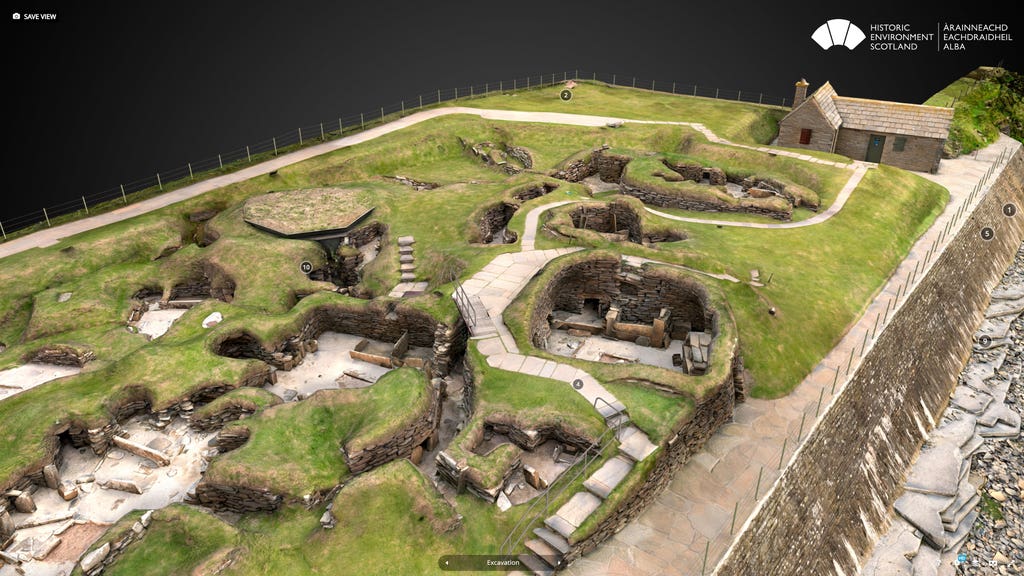
Visitors can take a virtual tour of Skara Brae through a new digital 3D model of the Neolithic site.
The Historic Environment Scotland (HES) model of the settlement in Orkney also lets people take a virtual look at house seven, the best-preserved house, which is not normally accessible to the public.
The model has been created through a process of laser scanning, using ultra-fast, high-resolution laser scanners which capture 3D spatial data.
To capture a photorealistic model, hundreds of overlapping images of the site are then combined with the 3D data, in a technique known as photogrammetry.
Al Rawlinson, head of digital innovation and learning at HES, said: “We’re really pleased to make this 3D model of Skara Brae available, which not only offers an innovative way to access this unique site but one which also showcases how we are using cutting-edge technology to monitor and maintain our historic environment.
“As we reflect on Cop26 and the challenges ahead, we want to demonstrate that in order to protect our past from the impacts of climate change, we must look to the future.
“Digital technology such as this will be a vital tool to help us better understand and manage the climate risks to our historic places and to share their climate stories.”
HES said that as well as offering a unique perspective on the “iconic site”, the digital model also allows users to explore how climate change and its impacts have shaped Skara Brae – from its discovery just over 170 years ago as the result of a severe winter storm, to the threat of coastal erosion from rising sea levels and increasingly frequent extreme weather events the site is experiencing today.
Users can also see how HES and its predecessors have responded to those challenges by exploring the sea wall which was constructed in the 1920s to protect the site from wave and storm damage, and which has been extended and repaired numerous times over the decades.
HES said the 3D technology used to create the model also has an important role to play in protecting the site for the future.
Since 2010, Skara Brae and the surrounding bay have been laser-scanned every two years by HES to monitor coastal change at the site.
The scanning data is then used to inform management and maintenance of the site, and is shared with Scotland’s national coastal mapping project, Dynamic Coast.
Dr Alistair Rennie, Dynamic Coast project manager, said: “Whilst the challenge posed by climate change is stark, new technologies like those deployed by HES increase our ability to monitor, learn, collaborate and find new approaches to become sea-level wise and adapt to our future climate.”
The model is available to view on Sketchfab here.
Follow STV News on WhatsApp
Scan the QR code on your mobile device for all the latest news from around the country